|
Reported Crop Circles for the State
of Washington -
Eltopia / Pasco, Franklin County (June 19, 1998)
Extraordinary 270 long by 200 wide formation with nine major circles (partially overlapping) connected by seven short pathways with much of the rest of the field scattered with 'randomly-downed' areas and 'grapeshot'. EM effects reported in area. W.C. Levengood reported finding node length changes consistent to fit the Beer-Lambert model of EM distribution, and significantly increased amounts of magnetic material were found in the soil samples. As the days went on after the formation was discovered, more and more of the field became affected by more randomly-downed flattened areas in the field. The formation was located on a slope, with the largest circle at the bottom. Four of the circles were flattened clockwise; five were counter-clockwise; several circles had two swirled centers.
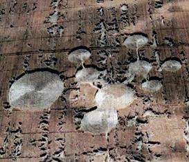
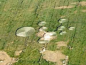
Crop
type: wheat
Source: ilyes
|
|
City
/ County / Date:
- Sacajawea
/ Pasco, Cowlitz County (1945)
- Moses
Lake, Grant County (August 21, 1964)
- Custer,
Whatcom County (January 1, 1965)
- Lynden,
Whatcom County (January 12, 1965)
- Harrah, Yakima County
(January 19, 1977)
- Centralia,
Lewis County
(April 1980)
- Kennewick,
Benton County
(May 28, 1993)
- Chehalis,
Lewis County
(July 8, 1994)
- Adna (1), Lewis County
(October 16, 1994)
- Adna
(2), Lewis County
(October 16, 1994)
- Chehalis,
Lewis County
(July 17, 1996)
- [Unknown]
(May 29, 1997)
- Coupeville
(1), Whidbey Island, Island County (May
26, 1998)
- Coupeville
(2), Whidbey Island, Island County (May
26, 1998)
- Eltopia
/ Pasco, Franklin County (June 19, 1998)
- Walla
Walla / Cottonwood Canyon, Walla Walla County (July 4, 1999)
- Burlington,
Skagit County
(September 8, 1999)
- Snohomish County (Fall, 2003)
- St.
John, Whitman County
(July, 2004)
- Wilbur,
Lincoln County
(June 27, 2007)
- Wilbur,
Lincoln County
(July 23, 2009)
|